
A user may choose to set Outline Contours for use on this tab as well as use the 'Create Feature from Identified Feature' tool.
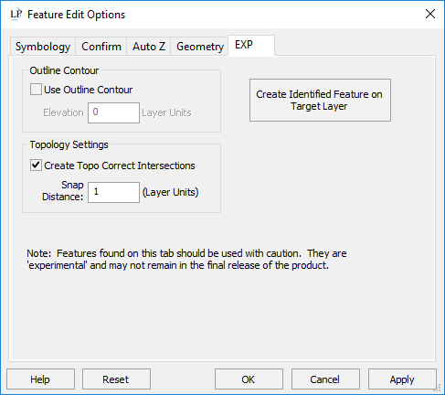
Setting an Outline Contour allows just a single contour at a specific elevation value to be created. If no contour is created at that elevation, the tool will not create a contour. Therefore, the user will see nothing in this case. To get the outline contour, the user sets a specific elevation value for that contour. The image on the left and below has a single digitized "pull line" at 110 feet designed to pull the TIN down to the river surface, effectively using it as a breakline. It is saved as a shape file as any breakline. The image on the red has a single red outline contour at the requested elevation of 110 feet.


WARNING: When the option is on, it is on for ALL projects until the user turns it off. It is used when generating contours. Therefore, if it is on and no outline contour is generated the user will see no contours at all. |
1. Click the Identify button on the Display and Navigation toolbar.
2. Click the feature (any kind of feature, including contours) that you want to create a feature from.
3. Make sure to have a target layer selected in the drop down on the Feature Edit toolbar.
4. Click the button to have the newly created feature drawn to that feature layer.
Perform on-the-fly topological vector joins with this setting.
When you draw a line that crosses an existing line that is on the same layer as the line you are drawing, a vertex will be inserted in both lines at the crossing point (or deflected, see the next bullet) with the Z of both vertices set to the elevation of the line being crossed, at the crossing point.
Deflection - If you set the Snap Distance to a value greater than zero, a check is made for existing vertices on the line being crossed. If a vertex does exist within the Snap Distance of the crossing point, the crossing point will deflect to this vertex. This feature allows you to avoid very closely spaced vertices at intersections as these can cause a topology anomaly.
Relating to the Split Tool - If checked when performing a Split Geometry, enter the tolerance distance value to use for removing any vertices that fall within that tolerance to the new split vertices. Any vertices within the Snap Distance of the crossing point are deleted. This is meant to prevent the clustering of vertices. The minimum possible of the Snap Distance value is 0.0
Right-Click option - In the Feature Edit Right Click Menu, there is an option to apply the Topo Correct Intersections tool after creating a feature. This is very useful in applying corrections or "fix" the crossings after the fact.
Note
|