
QCoherent Software, LLC


Modifying the Buffer Distance for Feature Classification


About Modifying the Buffer Distance

When an appropriate spatial relationship such as "Within a Distance of" is selected, the buffer distance must be specified. This distance is the criteria used to determine if a point satisfies the spatial relationship. The distance is in map units of the LIDAR data.

How to Modify the Buffer Distance

  1. Click twice (but not a double click) within the Distance column for the type value you wish to edit the distance for.
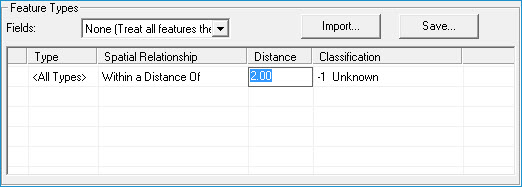

  2. When the text box appears, input the desired distance in map units.

  3. Press 'Enter' to commit the new buffer distance.

Tip

  • A buffer distance is not required when using the "Completely Within" relationship. The value within the distance column will appear disabled or gray in color.