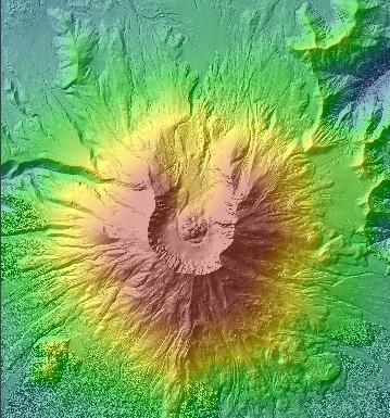
Hillshading is a way to determine the hypothetical illumination of a surface based on a given light source position in the sky. Positions on the terrain that are most exposed to the light source have high illumination or brightness values whereas terrain positions that are hidden or protected from the light source have low to no illumination or brightness. Hillshade values range from 255 (high illumination) to 0 (no illumination).
The exact algorithm used to produce the brightness value is the vector dot product operation between the normal vector of the plane of the terrain surface and the vector formed by the light source. The more positive the dot product, the more similar the two vectors are, resulting in higher brightness values. Negative values of the dot product indicate that the two vectors are pointing away from each other, thus yielding a 0 brightness value (Berg et al, 2000).
The position of the light source or sun is specified in degrees altitude above the horizon and azimuth. The hillshade or brightness value for a single terrain position may differ significantly for different positions of the light source. Such as the movement of the sun during the day and for different seasons. Much research has been conducted to correlate brightness values to solar radiation models for estimating the amount of solar energy falling directly onto a terrain surface (Burrough, 1998).
Hillshade and brightness values can be used to produce shaded relief maps that portray the three-dimensional aspects of the terrain accurately. Using a light source position of 315 degrees azimuth and 45 degrees altitude, one can produce the brightness values required to shade the terrain as it would appear in three-dimensions.
Shaded Relief Map using Hillshade or Brightness Values
References:
Berg, Mark de, Marc van Kreveld, Mark Overmars, Otfried Schwarzkopf. Computational Geometry. Springer, 2nd Edition, 2000.
Burrough, Peter A., Rachael A. McDonnell. Principles of Geographic Information Systems. Chapter 8, "Spatial Analysis Using Continuous Fields". Pages 200-202. Oxford. 1998.