About Hydrology Constraint Errors
After the drape is performed over the
LIDAR surface, initial checks can be made to ensure the input geometry was drawn in the correct direction. Performing these checks and being presented with errors can be very useful for enforcing rules and consistency in geographic databases.
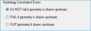
For example, a rule within the database may be that each stream feature must be stored in the downstream direction. In this case, the
FLIP geometry if drawn upstream setting will make sure the geometry is in the downstream direction but not fail if drawn in the incorrect direction. If you wish the system to fail if the geometry is drawn in the upstream direction, the
FAIL if geometry is drawn upstream setting should be used.
Contrasting to the first two settings, the
Do NOT fail if geometry is drawn upstream setting may be used to ignore the direction of the features stored in the database.
| Note When using the Do NOT fail... setting, please read the information available on the downstream constraint algorithm as a different behavior is used when geometry is drawn in the upstream direction. |
Learn more about the downstream constraint algorithm