
*This feature is available in the Advanced license level of LP360.
The Planar Surface Statistics Point Cloud Task attributes a drawn polygon with planar extraction statistics. It defines the best fit plane and computes the quality of fit values, which are stored as attributes on the shape file. It also serves as a diagnostic tool to facilitate the setting of planar filter settings.
1. Use the Add Files command to open the LAS files that contain the data you want to use.
2. Use the Add Task command to create a new point cloud task. When you are selecting a Task Type in the Add Point Cloud Task dialog, select Planar Statistics. Once you click OK, you should see the unique name that you gave your task selected in the list and the Planar Statistics property page displayed on the Point Cloud Task tab.
3. Specify the settings for the Planar Statistics operation in the Properties page that displays.
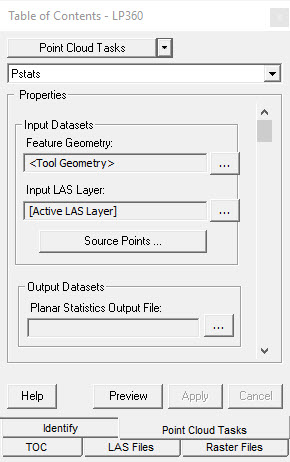
Input Data Sets
Feature Geometry - This is the input geometry for the point cloud task. It can be set within the I/O Manager by clicking the (...) button. The input geometry can be a Tool Geometry, File, or Layer.
Input LAS Layer - The input LAS Layer can be the "Active Layer" or any other LAS Layer. Clicking the "Source Points..." button displays the Points Filter dialog to set different filtering options.
Output Data Sets
Planar Statistics Output File - The computed planar statistics are output to a shapefile as attributes to the shape (feature). It can also be set within the I/O Manager by clicking the (...) button.
Statistics given in the output include:
Number of the Points - The total number of LAS points in the input geometry that are used to compute the planar statistics.
Classes of the Points - The output number of points for each class that are present in the input geometry.
Density - Density of the points in a given area, obtained by dividing the number of points with the area of the input polygon.
Normal Vector - The plane's normal vector. The input points will be used to fit an Eigen fit. The plane normal vector is the Eigen vector corresponding to minimum Eigen value. The vector is output as two parameters – Azimuth (North being zero and positive angles clockwise – e.g. compass heading) and elevation above the horizontal (nadir being 90 degrees). Thus Azimuth ranges from 0 to 359.9999 and elevation ranges from zero to 90 degrees.
Standard Deviation - The standard deviation of the points relative to the defined plane along the normal. This tells us how the point values are "spread out" on the plane. Lesser standard deviation means the points are more tightly clustered about the plane.
Outside 1 Sigma - Number of points that fall outside of the first standard deviation.
Lie within 1 Sigma - Number of points that fall within the first standard deviation.
Eigenvalues - The three Eigenvalues computed by the Principle Component Analysis (PCA).