
Breakline Source Layers
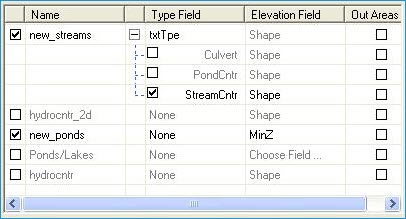
The breakline source layers are those layers within the map that can be
used as breakline sources. You can toggle
whether or not a layer is used as a breakline source and control specific
types of features within a single layer.
In addition to selecting a layer as a breakline source, the elevation field
must be selected for each layer and/or feature type. Typically, the elevation
field will be the "Shape" field which uses the Z coordinate
of each vertex within the feature geometry. You may also use other fields
to define the elevation for the entire feature such as for ponds or lakes.
Picture of the Breakline Source Layers
How
to toggle the use of a layer/source
Selecting
an Elevation Field
Selecting
a Type Field
How
to toggle the use of types
How
to toggle the out area state