When processing in ASPSuite, it is important to enter the correct base location and antenna information to achieve accurate results. The information entered in this dialog will be applied to the the image corrections and can introduce error if entered incorrectly. To properly use this dialog, it is important to understand a few things first.
Base Station Observation File
- The base station observation file contains raw satellite observation data recorded at phase center of the GPS antenna and must be in Rinex format to be used by ASPSuite (Version 2.11 through 3.02, although version 3.01 is preferred). This file is necessary to provide corrections to Loki data and must be recorded during the flight at an interval of 1Hz. Again, this is raw data with no offsets or corrections. ASPSuite will apply corrections based on the base station location entered, antenna height, and the base antenna calibration file.
- Two base observation files can be imported here and ASPSuite will join them together to form one observation file.
- This is useful for permanent base stations that record static data continuously and saves the observation file periodically (i.e. new file every hour or two hours). Example: If the base observation files are recorded from 9-10 am and 10-11 am, the two files will be combined to form an observation from 9-11 am.
- Two base observation files can be imported here and ASPSuite will join them together to form one observation file.
Base Station Location
- The base station location is the coordinate occupied by the base reciever when the observation file was recorded. If the coordinate was not previously established, users can submit their base observation file to an online GPS post processing service such as OPUS, AUSPOS, CSRS-PPP, etc.
- For OPUS users, the OPUS email can be copied and pasted into a text document and imported into ASPSuite. Be sure the text file has the word “OPUS” in the name.
- It is highly recommended to enter the ellipsoid height in ASPSuite and use the Geoid conversion option on output to reference your image heights to the geoid. If the geoid you need is not supported by ASPSuite, you may try to enter the geoid height for the base location, however, you may not get a valid trajectory to process, resulting in a Q0 solution.
- If manually entering the base coordinate in DMS format:
- Be sure to separate the degree, minutes, and seconds with a colon.
- Format: DD:MM:SS.ssssssss
- North latitudes are represented by a positive number, South latitudes are represent by a negative number.
- East longitudes are represented by a positive number, West longitudes are represented by a negative number.
- Be sure to select the units of the height before entering the value in the height field.
- Be sure to separate the degree, minutes, and seconds with a colon.
Note: LOKI is collecting in IGS(WGS84) since it is collecting GNSS information broadcast from the satellites. However, the results from ASPSuite depend on the datum of the base station coordinate that is entered. If one enters a base station coordinate in IGS08(WGS84), then the resulting trajectory and photocenters will be in IGS08(WGS84), but if one uses a GCS(NAD83(2011)) base coordinate, then the results from ASPSuite are pulled to NAD83(2011). If you use ASPSuite to read the base station coordinate out of an OPUS file (.txt version of the email from OPUS), the datum will be NAD83(2011) as the OPUS solution includes both a NAD83 and ISG08 coordinate, but when automatically read by ASPSuite, it always picks the NAD83 coordinate. The logic goes that if someone is using OPUS, they’re in the US and probably working in State Plane—all of which is normally NAD83(2011). If the user wants IGS08 (WGS84), use the “manual entry” option for the base location.
Base Antenna Height
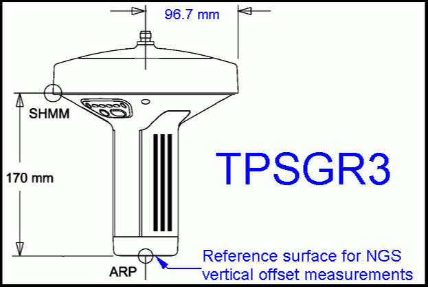
- The base antenna height is the vertical height of your base station’s Antenna Reference Point (ARP). The ARP is an identifiable location on the receiver (determined by the manufacturer) and is not to be confused with the slant height measure mark. The image below is a Topcon GR-3 and shows both the ARP and the slant height measure mark. As you can see, the difference between the two points is 170 mm. If slant height is used in ASPSuite for this base model, this could create 170 mm of error in the project.
- Many CORS stations and permanent base station coordinates are referenced to the ARP. In these cases, the Base Antenna Height will be zero.
- Your base antenna height should not include measurements to phase center.
Base Antenna Calibration
- Various elements of the base station can create signal advance/delays and can shift phase center slightly off of the physical sensor. The base antenna calibration file maps the point at which the carrier phase signal is received, and references it to the ARP. ASPSuite will read the antenna calibration file and apply the offset to the image heights. Every base model is different, so you will need to be sure you are using the calibration file for your base model.
- Calibration files can be download from the NGS library: https://www.ngs.noaa.gov/ANTCAL/index.xhtml
- Browse to and select the manufacturer of your base station.
- Right click on ANTEX click Save Link As.. and save the atx file.
- ATX is the only supported format for base antenna calibrations.


