44 articles TrueView Tutorials
A collection of how-to videos and tutorials to assist with GeoCue’s various drone mapping hardware and software offerings, such as the TrueView line of 3DIS and 2DIS systems, and TrueView EVO/LP360 Drone. Also includes posts related to the former AirGon Loki and ASPSuite.

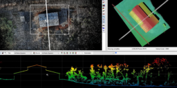
Enhancing Crop Management with TrueView LiDAR


TrueView Training Event: Part 4

During our March TrueView Training event, we recorded the training session with the presenter to have the training material available on demand. Since the training covers two days of various topics we have broken the event down into smaller pieces. This session covers model key points, deliverables such as contours, exporting data, uploading to Reckon,…
True View Training Event: Part 3
During our March TrueView Training event, we recorded the training session with the presenter to have the training material available on demand. Since the training covers two days of various topics we have broken the event down into smaller pieces. This session covers setting up a project and getting it ready for product generation, including…
TrueView Training Event: Part 2
During our March TrueView Training event, we recorded the training session with the presenter to have the training material available on demand. Since the training covers two days of various topics we have broken the event down into smaller pieces. This session covers field checking data, import settings, guest sensors, and project creation and processing.…
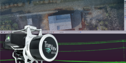
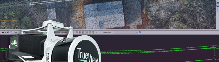
TrueView Training Event : Part 1

During our March TrueView Training event, we recorded the training session with the presenter to have the training material available on demand. Since the training covers two days of various topics we have broken the event down into smaller pieces. This first session covers the TrueView Ecosystem, hardware overview, flight planning, field operations, and field…
L1 Processing in EVO: Video Training Demo
The DJI Zenmuse L1 is an entry level system that integrates the Avia Livox LIDAR, IMU, and a 20MP mapping camera on a gimbal fitted to the DJI M300 RTK. When bundled with DJI Terra and GeoCue’s EVO software, it allows users to deliver quality data derived from non-complex environments. This video tutorial will walk…
Training: P4P-RTK PPK Workflow in True View EVO
This page is no longer updated. Please visit the updated page on the new LP360 Support Knowledge Base for the latest information. A short tutorial covering the Phantom 4 Pro (P4P-RTK) Post Processing Kinematic (PPK) workflow in TrueView EVO/LP360 Drone. The workflow covers some background on the workflow, the data files you need from your…
USDA LIDAR Training Part 10: Introduction to the Point Cloud Task and Feature Analyst
In this LP360 tutorial we provide an introduction to the Point Cloud Task (PCT) and Feature Analyst. How to add, modify, and organize your Point Cloud Tasks using Point Cloud Task Manager (PCTM). Plus, how to use Feature Analyst to review and navigate using features. This tutorial picks up from USDA LIDAR Training Part 9: Integrating the 3D…
USDA LIDAR Training Part 9: Integrating the 3D Viewer
In this LP360 tutorial we review integrating the 3D viewer into your workflow. Review of the legend command, symbology and filters in Live View, and displaying contours on the TIN. This tutorial picks up from USDA LIDAR Training Part 8: Integrating the Profile View and uses data downloaded as explained in USDA LIDAR Training Part 4: Introduction to LIDAR Server.…