Summary –> Avoid planning a mission when the KP Index forecast is 4 or higher.
What Is the KP Index?
The KP Index measures geomagnetic activity on a scale from 0 (quiet) to 9 (extremely disturbed), based on data from ground-based magnetometers. This index reflects the impact of solar flares and other solar events that release charged particles, which interact with Earth’s magnetosphere, causing potential disruptions to satellite-based navigation and communication systems.
You can monitor upcoming space weather events here:
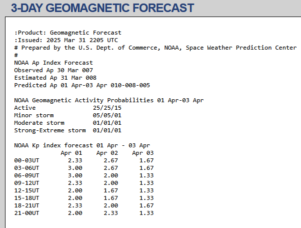
3-Day Geomagnetic Forecast
Last 30 days KP Index
Why the KP Index Matters for Drone Mapping
High-precision drone mapping missions rely heavily on Global Navigation Satellite Systems (GNSS). LiDAR units and mapping cameras mounted on drones use onboard GNSS receivers, often working with a ground-based base station.
When geomagnetic disturbances occur—typically when the KP Index rises to 4 or higher—GNSS signal reliability can degrade. This may result in:
- Signal loss or dropouts
- Reduced positional accuracy
- Time drift in GNSS data, affecting sensor alignment
- Faulty RTK/PPK corrections, leading to data inconsistencies
It’s important to note that these disruptions are not limited to aerial platforms. All GNSS-based surveying equipment can be affected from the geomagnetic activity.
