Problem:
Dropped images from Pixhawk drone flight and can’t georeference with dataflash logs.
Probable Resolution:
Create a new “Position File” that provides a row for each image filename, lat, lon, and elevation using our tool XYZsFromCAMEvents.
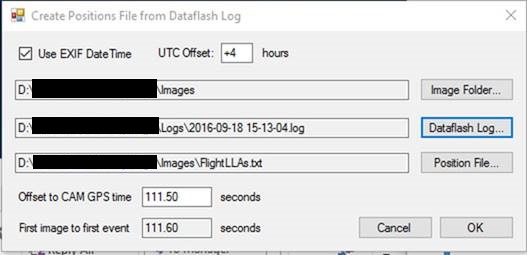
Create Positions File from Dataflash Log
Provide the “Image Folder” and the “Dataflash Log”. The default file is named “FlightLLAs.txt”. It DOES NOT create a “geotagged” folder, nor write anything to the image headers, but you can use the FlightLLAs.txt file with Pix4D or Photoscan to geo-reference the images. It uses timestamps in your image headers to sort out which image goes with which camera event. The camera events are in UTC time, hence you need to specify the offset from your time zone (i.e. +4 hours for Eastern time). The “111.50” is the number of seconds that the camera’s clock is off from UTC time. There’s not an installer; just unzip to a folder and run from there, or make a shortcut on your desktop.
Example FlightLLAs.txt:
IMG_0647.JPG,40.8051075,-77.6779944,460.93,60.59,-0.26,-12.32
IMG_0648.JPG,40.8052495,-77.6777329,460.37,60.03,1.67,-11.46
IMG_0649.JPG,40.8053901,-77.6774542,460.12,59.78,3.16,-12.21
