42 articles LP360 Geospatial Tutorials
A collection of how-to videos to assist with various tools, workflows, and analysis in LP360 Geospatial.

Watch a Video Overview of How to Assess and Enhance the Quality of Point Clouds with the Surface Precision Tool
The “Surface Precision” tool, included in the Business Intelligence Add-on package for LP360 Drone and the base package for LP360 Geospatial, is designed to provide a robust and automated assessment of the precision (or noise) on smooth surfaces within lidar data point clouds. It’s grounded on the ASPRS definition of surface precision as a measure of a lidar system’s…
Maximize Forest/Orchard Management with LP360’s New Individual Tree Segmentation Tool
Transform Your LiDAR Data into Actionable Insights on Tree Counts, Heights, and Locations LP360 Drone’s Individual Tree Segmentation (ITS) tool is a new addition to the Business Intelligence Add-on, designed specifically for forestry management and environmental monitoring. Leveraging advanced LiDAR data analysis, this tool can identify and catalog tree counts, locations, heights, and tree crowns across…
Boost Productivity with LP360 Cloud: Explore the Power of Automatic Ground Classification
New Graphical User Interface for LP360
Using Cloud Hosted Layers in LP360
New Upload to Support Feature for Quickly Sharing Files
How to Use the LandXML Export Feature in LP360
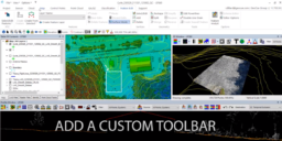
Customize the Ribbon in LP360