Problem:
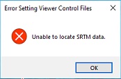
Attempting to load images into the viewer results in message, “Error Setting Viewer Control Files: Unable to Locate SRTM Data”.
In GeoCue 2013 , a new elevation service based on the Shuttle Radar Topography Mission (SRTM) was added to the GeoCue Server. This service provides elevation data at 30 m post spacing outside the United States and at 10 m post spacing within the United States. Coverage is provided from -70° to +70° latitude. We use this service in numerous GeoCue applications when an approximate ground elevation is needed in an algorithm. An example is projecting the ground footprints of images.
Probable Resolution:
The SRTM data is either located in the “<GeoCue Common>\Support Data\SRTM” folder or in the location as specified in the AuxLocation.txt found therein. If the viewer cannot find SRTM data that covers the image location, then it will throw that error message. Check to ensure that SRTM data covering the project area is in either of those locations and that they are accessible by the user.
If you don’t have the SRTM data you can downloaded and install it. It is quite large in size, but is publicly available.
