Trimble CenterPoint RTX © is a global GNSS technology that provides centimeter-level positioning, worldwide, at any time. Users may use this service, much like the United States NOAA’s Online Positioning User Service (OPUS), or other national and private services, and submit a base station RINEX file to obtain a coordinate for that survey nail/reference mark, which can then be entered into the True View EVO/LP360 Drone Survey Nail Manager for processing trajectory solutions.
For TrueView 3DIS systems running POSPac UAV desktop, one can run Trimble CenterPoint RTX from directly within the generated POSPac project, however, to integrate its usage for all user this service option was integrated within the POSPac Processing Wizard in TrueView EVO/LP360 Drone as of v2022.1.22.0.
TrueView EVO/LP360 Drone:
- On the second page of the POSPac Processing Wizard simply toggle the Base Station Location so the location is “Computed using Trimble CenterPoint RTX” to use the computed position rather than entering a survey nail/reference mark in the Survey Nail Library and selecting a nail on this page of the wizard.
POSPac Desktop:
- Open the POSPac project
- Select the base station
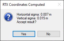
- Right-click and select Compute PP-RTX coordinates
- It’ll provide a summary on the quality.
- Select yes to update thebase coordinates in the POSPac project with the new values.
- POSPac will download the xml version of the report, like you would get by going to the website directly, and puts it into the C numbered folder found beneath the POSPac project.
- You’ll also find a rtxCoords_StationID_Mission 1.log in the extract folder.

