LIDARgrammetry is a term coined by GeoCue for using the intensity information as the source data for generating stereo models of the project area directly from the LIDAR data itself rather than from ancillary imagery. By creating appropriate stereo pairs from the LIDAR intensity images, it is possible to generate stereo models that can be directly exploited using existing photogrammetric workstations and the traditional photogrammetric workflow in areas such as feature extraction or breakline compilation. Using the LIDAR intensity data to generate stereo models allows data providers to improve the overall efficiency of their LIDAR data processing while also allowing established mapping firms to continue to exploit their existing infrastructure when working with LIDAR data sets.
The typical LIDARgrammetry stereo workflow:
- Populate LAS Working Segments from the LIDAR source files.
- Create S-Tiles covering and generated from those working segments.
- Edit the S-Tiles:
- Using the “Stereo Edit” step if the stereo compilation software exists on a GeoCue enabled machine.
- Using the “Export Stereo Model” to export the stereo project for edit on a non-GeoCue machine.
The “Export Stereo Model” utility step supports export to:
- DAT/EM Summit
- Z/I ImageStation (ISPM Project)
- BAE SOCET SET
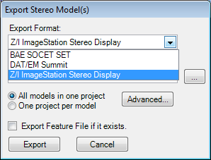
Export Stereo Models
The export requires the applicable AT software on the GeoCue machine running the step since the process uses the specific manufacturer DLLs, but it doesn’t need to be licensed. Both DAT/EM and ImageStation have remained compatible regardless of versions of either GeoCue or the stereo software. SOCET SET on the other hand has varied slightly and so requires GeoCue 2013 SP1 to export SOCET SET v5.4 or earlier projects. As of GeoCue 2013 SP2, GeoCue no longer requires SOCET SET to be installed and will always export SOCET SET v5.6 projects.
Important note: GeoCue currently supports direct editing in SOCET SET versions prior to 5.6 only. Should you wish to use GeoCue for stereo editing with later versions of SOCET SET please contact us.
