Problem:
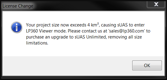
The LP360 sUAS license level limits the project size to 4 km². The LP360 EVO, EVO 3DIS, and LP360 Drone license levels limit the project size to 10 km². If LP360 determines the project size exceeds this limitation, this informational dialog, “Your project size now exceeds 4 km², causing sUAS to enter LP360 Viewer mode” or “Your project size now exceeds 10 km², causing active license to enter True View EVO Viewer mode” appears when adding LAS files to the project. LP360 will then revert to the Viewer License level and user functionality will be limited.
Probable Resolution #1:
If the project size exceeds the size limitation for the license level, contact Sales@LP360.com to upgrade your license to LP360 Advanced or purchase an Unlimited addon license for LP360 Drone to remove the project size limitation. LP360 Drone subscription license users may purchase the Unlimited addon license directly from the LP360 Portal.
Probable Resolution #2
You know your project is smaller than 4 km², or 10km² for EVO, EVO 3DIS, or LP360 Drone, but you still receive this message. This issue is caused by the absence of spatial reference information in the header of the LAS file. If the units are not written to the header of the LAS file when it was created, LP360 will presume the units are meters. Hence, a project that is 4,000 x 4000 feet, will get interpreted as if it were 4,000 x 4,000 meters and exceed the project size limitation for the LP360 sUAS license level. The following steps explain how to correct this issue.
- Open LP360 and add the LAS files. You will receive the message shown above. Select OK and LP360 will enter viewer mode.
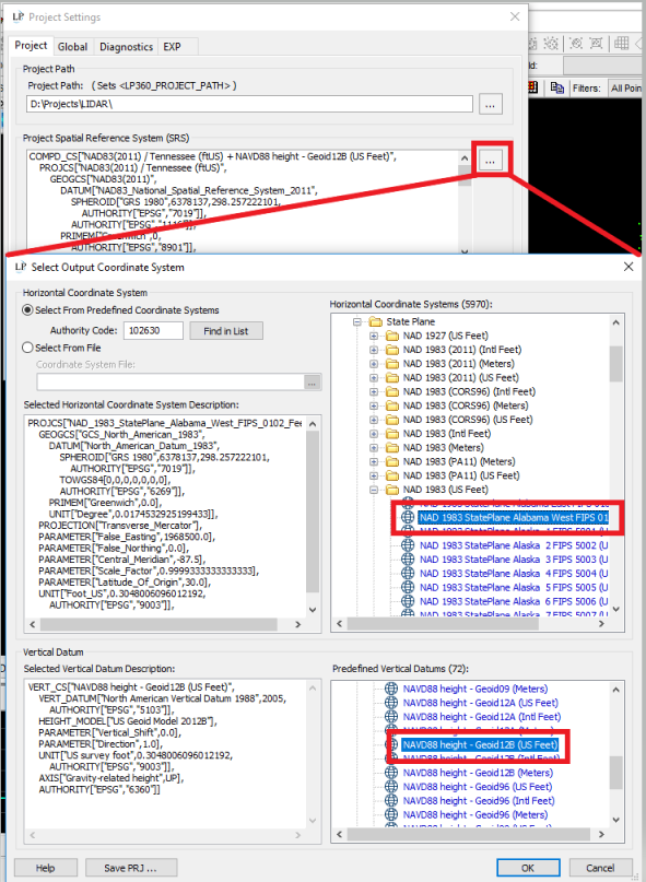
- Open the Project Settings dialog (File -> Project Settings) and select the ellipses button to the right of Project Spatial Reference System (SRS) to access the coordinate system manager.
- Choose the correct Spatial Reference System for your project files. Once the horizontal and vertical SRS has been set for the project, select OK and select OK again to dismiss these dialogs.
- Right-click on the LAS layer in the table of contents and click the option to “Set layer SRS using Project SRS”. Click yes to confirm.
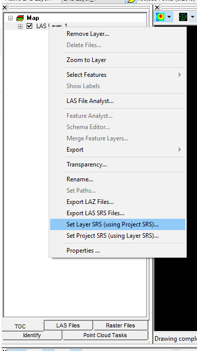
Set layer SRS using Project SRS
- Save your current LP360 Project (File -> Save Project As).
- Open LP360 License Manager (File -> License Manager) and “Check Out” the sUAS license again.
- LP360 should no longer be in Viewer mode, and the correct project size should be displayed in the Project LAS Area (File -> Project Settings).
Probable Resolution #3:
The size is computed from the sum of the MBR (minimum bounding rectangle) as written in the header of each LAS file on the active LAS Layer. If you have an odd shaped area or a meandering corridor and the data is all in a single LAS file then you can encounter where the size will exceed the limit, even for a very small amount of data since the void area is included in the computation. LAS files generated by EVO following our recommended workflows and best practice are usually by flight line or smaller tiles of data (after smoothing) so as to best avoid the inclusion of the void areas in the project size computation. Review the file layout for the active LAS layer of your project by using the Display Boundaries tool on in the main LP360 toolbar to display the MBR.
Probable Resolution #4:
If you only encountered the size limit after running a Post Process Metashape for EVO (MfE) job that included the generation of a point cloud, you may need to enable the Tile Point Cloud option under the Metashape for EVO -> Advanced Settings -> Point Cloud Settings using a small enough size not to generate files that cover a large area, but have little data in them.
