Question If LP360 for Windows, or LP360 for ArcGIS experiences a program crash what steps should then be taken to make use of the crash dump files to help determine why the crash occurred? Answer The best way to determine why LP360 experienced a program crash is to locate the program error report and dump files and…
This page is no longer updated. Please visit the updated page on the new LP360 Support Knowledge Base for the latest information. There are many tools and keyboard shortcuts that exist within the LP360 product suite, including LP360 for ArcGIS, LP360 Geospatial, LP360 for sUAS, TrueView EVO/LP360 Drone. Remembering all of them and where to…
What is a Point Cloud Task (PCT)? A function (Extract ground, Conflate Line) that operates on points, rasters, and/or vectors. A task can be a filter and/or an extractor. A filter classifies or changes the classification values for points (e.g. classify ground). An extractor extracts information from the point cloud data into vector, image or…
The Tree Segmentation tool can be used on a forested dataset to identify and count the number of trees within an area of interest while also generating two output files: a LAS point cloud to visualize the individual trees and a point feature that contains the height and crown surface area of each tree with…
In configuring a set of control points or check points for use in the Control Points Report Dialog, it is best to follow the convention below to make the most use of the Drive Mode shortcuts available within the toolbar for navigation and filtering. The fields either need to exist in the shapefile or may…
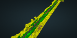
For comparing multiple datasets in a single profile view in the exact same location, all of the Point Source IDs will need to be edited and combined into one LAS layer on import. Before bringing this exercise, import all the desired datasets into a single project, then copy the LAS layers (right-click the layer, selected…
An LPLAS file is a new file type for point cloud data that is compatible with any software able to read LAS. This new file format also follows the ASPRS standards for the most up to date specifications for LAS. Any existing LAS file can be converted to the new LPLAS format by running the…
When LP360 is initially installed, there are several default files that also get installed. These default files include Point Cloud Tasks, Conflation Tasks and Display Filters. The files can be found in your “%AppData%\LP360” folder. The tasks and filters are stored in XML files and each time a new task or filter is created the information is appended…