GeoCue Support » LP360 Geospatial » LP360 Geospatial Tools, Tips and Workflows » Page 3
A Ground Control Point (GCP) is a monumented point for which geodesic coordinates are known with a controlled accuracy and precision. It can be provided by a National Geodetic Authority or made by the user. Several topographic survey techniques can be used to determine the coordinates of a GCP (GNSS, geodetic network adjustment from distance,…
LP360 contains a number of “non-obvious” commands (usually keyboard activated shortcuts). This page has been updated for LP360 v2022.1. General: Live View – When opened in one view can be left open and by clicking the Live View button in a different view the settings will change to that view’s current stateChange Languages – See the separate…
While exporting data from LP360 using the Export Wizard a COM Exception, “Exporting LAS files failed (22684)”, is encountered. “Caller’s Message:Exporting LAS files failed. (22684)Exception Information:HRESULT: 0x80004005Unable to retrieve extended COM error information.” Is there another file in that location with the same name? Do you have any LAS files that contain only a single…
Relative vertical accuracy, or flight line offsets, or the swath-to-swath fit between flight lines or drive passes can be qualitatively assessed using dz images. Or quantitatively assessed by exporting and analyzing the values. The USGS LiDAR Base Specification has evolved over the years with some different recommendations for evaluating interswath (overlap) consistency, and there are…
Attempting to save an LP360 project results in “An error occurred updating the Project Catalog with Project:”, followed by “Detail: Error: Unable to open Projects File. Project not added to list. C:\ProgramData\LP360\PMProjects.json”. The global projects file, “%ProgramData%\LP360\PMProjects.json”, used by the LP360 Project Manager was created with administrator permissions when LP360 or TrueView EVO first launched…
Some LP360 Point Cloud Tasks (PCT’s) were originally designed for older manned lidar datasets, which have significantly lower point density than modern sUAS datasets. TrueView and other sUAS sensors have the capability of producing much denser point clouds, so these processes can take much longer if running on the entire dataset. A common strategy and workflow…
Classify by Elevation Quartiles In the Classify by Statistics PCT, the user can set the output of outliers and quartile classification using the standard output class/flag dialog. A little info regarding quartiles: https://byjus.com/maths/quartiles/. The section applicable to Quartile classification is shown in Figure 1: This classifier works as follows: The area to be processed (as determined…
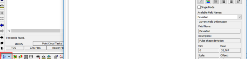
Officially introduced in the LAS v1.4 specification, Extra Bytes is a mechanism which allows a developer to define extra data fields of various types. They are a means to extend the LAS format to add additional information to each point, literally
The Image Explorer Drive Method determines the method used to sort matching imagery. Range will sort images by shortest distance from the camera position XYZ to the projected XYZ. Photo Center will sort images by the shortest distance from the photo center to the projected raster column and row. GPS Time will sort images by…
When generating a GeoTIFF orthomosaic raster using Metashape or importing a large ortho from third party software into LP360 or TrueView Evo, the initial file is written in BigTIFF format which is incompatible with some CAD software packages, including Civil3D. There are also size considerations to be factored in as some orthos can be dozens…