Author: GeoCue Support Page 13 / 76
GeoCue Support has written 753 articles

3D Accuracy with LP360
A Ground Control Point (GCP) is a monumented point for which geodesic coordinates are known with a controlled accuracy and precision. It can be provided by a National Geodetic Authority or made by the user. Several topographic survey techniques can be used to determine the coordinates of a GCP (GNSS, geodetic network adjustment from distance,…
POSPacCloud: Authentication Failed
Attempting to run POSPacCloud to process a sensor trajectory solution in LP360 Drone, formerly TrueView EVO, results in an authentication failed error, “An error occurred running POSPacCloud.exe: C:\Program Files\Applanix\POSPac Cloud\POSPacCloud.exe AUTHENTICATION_FAILED Unexpected character encountered while parsing value:” Please ensure POSPacCloud has installed when you installed LP360. Or manually install using the POSPacCloud setup, POSPacCloud_PROD_v0.0.xx.zip, available under…
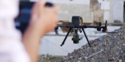
Improve 3D Accuracy in Drone LiDAR projects with Accuracy Star
Add an RSS Feed to Outlook
Enhancing Crop Management with TrueView LiDAR


Strip Adjustment for Multiple flights
Strip adjustment can be used to adjust not only the flight lines within a flight, but also adjust multiple flights. This article shows how to use strip adjustment to more than one flight. For how to use Strip Adjustment or the method and context behind Strip Adjustment. 1. Requirements There are two requirements needed to adjust…
How to use Strip Adjustment
In this article it is explained step by step how to use the Strip Adjustment tool. 1. Introduction Strip Adjustment is a module available in LP360 Drone starting from v2023.2 and is only available within the TrueView workflow. This means that only TrueView and microdrones data processed in LP360 Drone can benefit from Strip Adjustment.…
Utilizing NOAA CORS as a base for your TrueView Project
When a base station file is corrupt or incorrectly recorded (for example: the observation rate is not set correctly or the battery fails), a user may elect to use the efficient SMARTBase or PP-RTX for post processing the sensor trajectory solution for your TrueView, microdrones, guest sensor Cycles, as applicable. Alternatively, with more effort and…
How to Process L1 Data in LP360 Drone