GeoCue Support » Drone, Mobile and Handheld Mapping » TrueView Tools, Tips and Workflows » Page 4
Introduction LP360 Drone: At the end of the Post Processing Wizard in LP360 Drone, formerly TrueView EVO, the GNSS information is processed in an attempt to generate a good quality rover position file for use in downstream processing. While processing the GNSS solution a command window displays the quality level (Q level) for each epoch…
1. Introduction In this article we will explain step by step how to process a TV540 dataset in LP360 Drone. The idea of the article is to serve as a quick user guide on processing. This article will not explain in detail each of the settings available in each step, that can be found either…
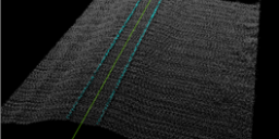
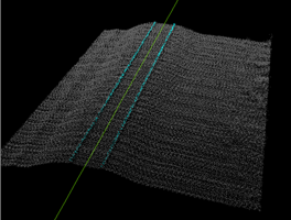
Introduction Three-dimensional point clouds of railways can be used to examine potential hazards along the railway infrastructure, identify track distortions and areas in need of maintenance. LP360 Drone includes tools to automatically extract a rail alignment (centerline) feature as a polyline as well as classify “top of rail” from LAS files derived from Laser Intensity Detection and Ranging…
In LP360 Drone, formerly called TrueView EVO, the user has a number of options for post-processing the sensor trajectory solution for a TrueView, microdrones, or guest sensor. Here is a quick comparison chart of the options. For more details on each method click on the name in the header to take you to their descriptive…
Attempting to run POSPacCloud to process a sensor trajectory solution in LP360 Drone results in an authentication failed error, “An error occurred running POSPacCloud.exe: C:\Program Files\Applanix\POSPac Cloud\POSPacCloud.exe AUTHENTICATION_FAILED The request was aborted: Could not create SSL/TLS secure channel. When installing LP360 an incorrect version of POSPacCloud was installed separately that was incompatible with the latest…
Introduction GeoCue customers using TrueView or microdrones products can upload their archived Cycles to LP360 Cloud for efficient long term backup. Each customer account has an LP360 Online account with an account administrator that is e-mailed credentials when the first product is purchased. The LP360 Online account provides access to all LP360 Online services. The…
The LP360 sUAS license level limits the project size to 4 km². The LP360 EVO, EVO 3DIS, and LP360 Drone license levels limit the project size to 10 km². If LP360 determines the project size exceeds this limitation, this informational dialog, “Your project size now exceeds 4 km², causing sUAS to enter LP360 Viewer mode”…
This page is no longer updated. Please visit the updated page on the new LP360 Support Knowledge Base for the latest information. LP360 is a 64-bit Windows® desktop application used for many years by the LP360 Geospatial community for processing traditional aerial, mobile, and terrestrial tripod laser scanner data. The LP360 Drone community is the…
Question If LP360 for Windows, or LP360 for ArcGIS experiences a program crash what steps should then be taken to make use of the crash dump files to help determine why the crash occurred? Answer The best way to determine why LP360 experienced a program crash is to locate the program error report and dump files and…
This page is no longer updated. Please visit the updated page on the new LP360 Support Knowledge Base for the latest information. There are many tools and keyboard shortcuts that exist within the LP360 product suite, including LP360 for ArcGIS, LP360 Geospatial, LP360 for sUAS, TrueView EVO/LP360 Drone. Remembering all of them and where to…