LP360 contains a number of “non-obvious” commands (usually keyboard activated shortcuts). This page has been updated for LP360 v2022.1. General: Live View – When opened in one view can be left open and by clicking the Live View button in a different view the settings will change to that view’s current stateChange Languages – See the separate…
The TrueView 515vB Hardware Users Guide covers the ins and outs of installing and operating the latest version of the GeoCue TrueView 515 3D Imaging System (3DIS) (LIDAR/Cameras). For the original version, please see the TrueView 515 Hardware Users Guide. Contents About GeoCue ……………………………………………………………………………………………………………………….4About LP360 Drone…………………………………………………………………………………………………………………5About TrueView Reckon ………………………………………………………………………………………………………….6A TrueView Cycle…………………………………………………………………………………………………………………… 7System Configuration File (SCF)……………………………………………………………………………………………. 7FCC and IC…
During sensor trajectory processing, POSPac fails with an unexpected error if a Trimble R12i base station T04 file is used, showing the error, “Error in 81196f9b39144c98ad71538c0c437545STDERR bpointID Parameter name Could not set the base station position because a station with ID DEFAULT was not found in the project. Batch error project … failed to process…
One advantage of the Ortho Mapping tool and the Job Manager in LP360 Drone is the ability to view processing logs for each job. This comes in handy when a job fails and troubleshooting is required. One error that may be displayed in the processing log is “AttributeError: ‘str’ object has no attribute ‘items’“. The…
TrueView Evo has now become LP360 Drone. While the functionality of the software remains in place, updating from TrueView Evo 2022.1.39.0 to LP360 Drone 2022.1.60.0 requires the removal of Evo before installing LP360. If this is not done properly, it could lead to an error message stating “TrueViewEvo.exe – Entry Point Not Found“; “The Procedure…
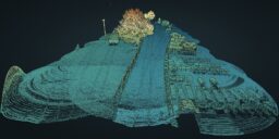
SEE HOW TO EXTRACT RAILS IN LP360 AND VIEW THE 3D POINT CLOUD With the merge of mdInfinity into LP360, users of Microdrones fully integrated systems can take advantage of the capabilities of LP360 Drone to transform raw flight data and generate colorized, georeferenced 3D LiDAR point clouds. In addition, the software allows you to geotag the imagery…
While exporting data from LP360 using the Export Wizard a COM Exception, “Exporting LAS files failed (22684)”, is encountered. “Caller’s Message:Exporting LAS files failed. (22684)Exception Information:HRESULT: 0x80004005Unable to retrieve extended COM error information.” Is there another file in that location with the same name? Do you have any LAS files that contain only a single…
Recommended True View EVO/LP360 Drone system requirements for processing data from TrueView, microdrones, and guest sensors: Windows Version 10, Professional (64-bit) or Windows 11 Professional, or their server equivalents. i7 or equivalent CPU. The more cores, the faster the processing 16 GB RAM (32 GB recommended) Nvidia Graphics recommended but not required Graphics must support…
This page is no longer updated. Please visit the updated page on the new LP360 Support Knowledge Base for the latest information. During POSPac processing in TrueView Evo/LP360 Drone, user encounters, “An unexpected error occurred creating the POSPac Export File” while processing the Post Process Trajectory File. This error is likely due to a corrupted…